During the 1990s the Irish state achieved economic lift-off, with almost double-digit growth each year. Outward migration flows not only halted, but actually reversed, leading to an unforeseen surge in demand for residential and commercial spaces. Notably, much of this pressure occurred in the Greater Dublin Area, where growth was most focused.
A study at the turn of the century noted that the preferences of both businesses and ordinary homeowners were, ‘determined primarily by access to vital infrastructure’. Deficiencies in administrative coordination had already, however, generated substantial urban sprawl, particularly as ‘management of the peripheral development of the region is seen to be inadequate’.
Matched by weak bureaucratic control, low density real estate development associated with sprawl occurred only with ‘the private motor car becoming the preferred or only method of transport in such areas’. The authors concluded that ‘previous commitments made to principles of sustainable development are null and void (Shiels and Williams, 2000).’
I – Sustainable Development
In attempting to resolve this the national policy document Sustainable Development: A Strategy for Ireland (Department of the Environment, 1997), had advocated minimising growth in transport demand, ‘and it was recommended that this be a leading consideration in future land use planning (Murphy, 2004)’.
The National Spatial Strategy (2002) further addressed the unchecked growth, recommending mixed-use and higher density development, which would focus on public transport centres. It also recognised a need to minimise urban sprawl, and maintain physically-compact and public transport-friendly cities. This stated policy of moving away from car-dependent development was refined further in the ‘2004 Regional Planning Guidelines for the Greater Dublin Area, 2004-2016 (Phillips et al, 2004)’, which emphasised the need for new developments to be sited along high qualify transport corridors.
Although access to public transport, and lax planning controls, have been major factors in bringing about car-dependent real estate developments, other aspects of governance have also contributed. Not the least of these have been fiscal policies in the housing area, which ‘have tended to systematically favour and support new building at greenfield locations’, these included inter alia ‘preferential taxation treatment in terms of stamp duty and first-time buyers grants (Williams and Shiels, 2000)’.
Not only are such developments car-dependent, but ‘allied with an increased dependence on edge city retail development encourage car usage and complement the edge city employment pattern in a combination which negates stated policies on sustainability (Wiliams and Shiels, 2000)’. Hence, a vicious circle develops wherein cars are not only required for accessing new developments, but this spawns further car-dependency, both by virtue of the remoteness of the location in the first instance, and because the car becomes, far and away, the most convenient way of getting around.
Between 1994 and 1999, with rising prosperity, rates of car ownership rose by a remarkable 164% in the Dublin area, but this was nothing compared to the exponential increases in outer commuter areas, such as County Louth, where ownership soared by 433.5% (Williams and Shiels, 2000).
With Dublin house prices soaring by 136% between 1994 and 1999 (Department of Environment and Local Government, 2000), a commuter belt emerged spanning an area within ninety kilometres of the city, and encompassing towns such as Gorey, Portlaoise, Mullingar, and Dundalk. Clearly, therefore, it is not that real estate development occurred simply because of road transport access, but because of the absence of affordable housing in central locations.
II – Deindustrialisation of the Urban Core
Another factor has been the deindustrialisation of Dublin’s city centre, in line with international trends, with plants, and hence places of work, relocating to the edge of the city (Murphy, 2004). Such changing commuter patterns have also placed a premium on car-based travel.
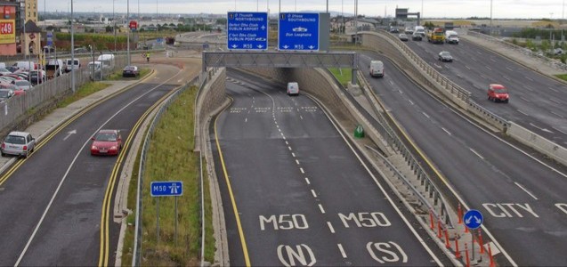
The facilitation of real estate development has not, however, been occurring on an entirely ad hoc basis along existing roads; a Dublin Region ‘edge city’ developed along an entirely newly-built road, that now forms ‘the central axis of Dublin’s edge city’, namely the M50 C-ring motorway (Williams and Shiels, 2000).
As with the residential sector, it appears that commercial growth was greatly driven by a lack of supply within the traditional downtown Dublin business district, where in 1999 vacancy – and hence supply – was estimated to be as little as 1.45% (DTZ Sherry FitzGerald, 1999).
The centrality of the M50 to Dublin’s new business axis is referred to in Chaos at the Crossroads by Frank McDonald and James Nix’s polemical account of Ireland’s construction craze. The authors claimed that ‘Gold-plating of greater Dublin through the NDP’s roads programme’ copper-fastened the location’s distinct advantage as the focal point of the new ‘hub and spoke’ motorway network that was rolled out under the NDP’s national roads programme.
Hence, while the Dublin region commercially developed, they contend that many areas were bypassed – albeit new developments could occur along the spokes.
Moreover, the projected cost of the national roads programme began at €6.8 billion, before climbing to €16 billion at the time of McDonald and Nix’s publication, who noted that the Department of Finance in 2002 had warned internally that the ultimate cost would likely rise to €22 billion, an estimate which has since been proved correct.
As subsequently described by the National Roads Authority in ‘A Decade of Progress 2000 – 2010’, overall this has meant ‘All told, over 1,200 kilometres of motorway and over 400 kilometres of single carriageway and link roads were built’, during these years, and also ‘some 100 grade separated junctions’.
III – The Poor Relation
In contrast to the apparently endless cash shovelled into a seemingly never-ending roads programme, not one kilometre of greenfield heavy gauge railway was built. Instead, as noted by McDonald and Nix, additional commuter trains were only laid on in response to demand in outer-lying towns such as Gorey, Portlaoise and Mullingar; matching this was NRA resistance to bus lanes being developed along national routes.
As is noted also by McDonald and Nix, public transport is at a fundamental disadvantage when dispersed development occurs. This leads to ‘empty bus syndrome’ wherein the further a bus has to travel at peak times in order to pick up passengers, the less viable the service becomes.
Hence, when the Gorey Local Area Plan was published in 2002, and the population had risen by 44% between 1996 and 2002, it noted ‘that ‘as much as 70% of the town’s new residents commute to Dublin on a daily basis, mostly by car (McDonald and Nix, 2005)’.
Gorey could be viewed as a microcosm for what was happening elsewhere; McDonald and Nix recall how thirty-seven acres of agricultural land beside an interchange on the new Gorey bypass, belonging to the elderly mother of a Fianna Fáil councillor Lorcan Allen, was rezoned without public consultation, and without any significant repercussions for the councillor.
Thus, the car-dependent pattern of commuter housing along or close to the new motorways, leading away from the main urban centres, became a feature of development in that period – with Killenard off the now M7 in Co. Laois described as the ‘most shocking’ – while separately McDonald and Nix predicted that much of Westmeath’s development would likely be a ‘necklace of villages’ along the M6 route.
Notwithstanding the relationship between property development and new road schemes, the effect of good public transport on the value of real estate also became apparent – albeit belatedly.
A 2008 paper by Karen Mayor et al evaluated the financial impact of suburban rail transport – including the two light rail Luas lines – on the price of nearby property. At the time of the 2007 census a mere 7% of commuters in the Greater Dublin Area travel by rail, in contrast to the 49% traveling by private car.
In total 6,956 house prices ‘covering most of the Dublin area’ were assessed to evaluate appreciation in house value attributable to proximity to the rail network, bearing in mind other environmental amenities, and the structural characteristics of the houses themselves.
They found, ‘properties within 500 metres to 2 kilometres of a light rail station are found to sell for between 7% and 17% more than properties not in proximity of the station’, with proximity being a decisive factor – typically 12–17% when within 500 metres.
Yet when the DART was analysed, the authors found the ‘station premium is approximately 5%’ – a lower figure they attribute to good buses services already existing, and also the antiquated rolling stock. A further complicating factor was that while there seemed to be a correlation between demand and proximity to functional stations, ‘train tracks however are considered a disamenity and reduce the price of a dwelling’.
The authors concluded that ‘rail connections have value to home owners, but also that not all connections are equally valuable (Mayor et al, 2008)’.
IV – One-off Housing
No review of the relationship between property development and transport in Ireland in recent years is complete without some assessment of the phenomenal amount of rural bungalows being built, where ‘single rural dwellings (SRDs) dominate the rural housing profile, accounting for all dwellings in some Electoral Divisions and 80% on average’ (Keaveney, 2007).
Keaveney notes:
Clearly, accessibility to urban centres and by road networks has continually been a driving force in the location of housing. Densities in 2002 reached up to 25 households per square kilometre along the national road network and adjacent to urban centres.
Hence while many of these houses are supposed to be for the benefit of the local economy, it seems reasonable to deduce that a premium is placed on good road access – although this is a variable factor that is probably best determined on a case-by-case basis.
Despite high level official policy statements and aspirations regarding sustainability, the institutions of the state encouraged private car transport in a manner that not only subverted such sentiments, but also opened up virgin lands for property developments that otherwise would have been inaccessible, uneconomic, or both.
While a genuine shortage of supply combined with economic prosperity drove demand, these two factors alone would not have created car dependent outer suburbs and developments. Without aggressive promotion and development of roads by the authorities – usually requiring property developers to provide car spaces – it would not have been possible in many instances to construct the low-quality unsustainable sprawl we now live with.
References
Brendan Williams and Patrick Shiels, ‘Acceleration into Sprawl: Causes and Potential Policy Responses’, ESRI, Dublin, June 2000.
Department of the Environment, Ireland, Sustainable Development: A Strategy for Ireland, Department of the Environment, Dublin, 1997.
Department of Environment and Local Government, Annual Report, 2000.
DTZ Sherry FitzGerald, Annual Report, 1999
Karen Keaveney, ‘Contested Ruralities: Housing in the Irish Countryside’, PhD thesis, National University of Ireland Maynooth, 2007.
Karen Mayor, Seán Lyons, David Duffy and Richard S.J. Tol ‘A Hedonic Analysis of the Value of Rail Transport in the Greater Dublin Area’, Journal of Transport Economics and Policy, January, 2008.
Frank McDonald and James Nix, Chaos at the Crossroads, Gandon Editions, Dublin, 2005.
Enda Murphy, ‘Spatial Restructuring and Commuting Efficiency in Dublin’, Trinity College Dublin Centre for Urban and Regional Studies, 2004.
National Roads Authority, ‘A Decade of Progress 2000 – 2010’, Dublin, 2010.
Tom Phillips, Atkins, the Urban Institute Ireland and Goodbody Economic Consultants, ‘Regional Planning Guidelines for the Greater Dublin Area’, 2004-2016, Dublin 2004.


